We’ve all heard of the famous treks of Himachal and Ladakh, but have you ever wondered about the beautiful treks in Sikkim? Sikkim is abundant in natural beauty, and mountains provide a great opportunity to hike the Himalayas of Sikkim. Goechala Trek is one of the most beautiful treks in Sikkim that we will delve into in this blog. If you plan this trek, read on to know every detail about its track!
The Famous Goechala Pass of Sikkim
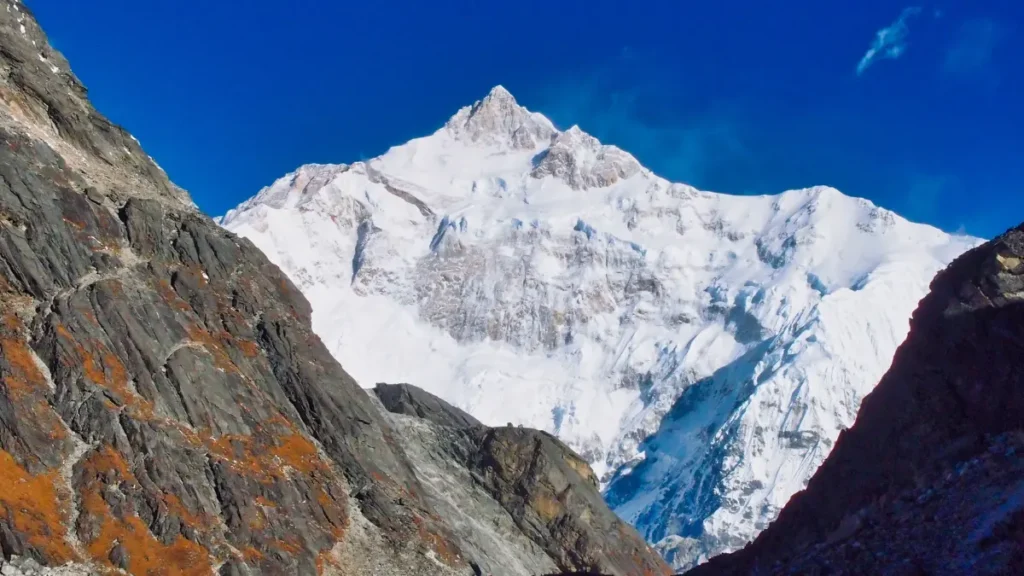
Goechala is a high mountain pass in the Himalayas located in the Gyalshing district, Sikkim, India, at an elevation of 4940 metres (16,207 feet). From the pass, which doubles as a base camp for those hoping to summit the mountain, one can see the southeast face of Kanchenjunga, the third-highest peak in the world. It is said that the Goechala’s vista touched government officials so much that they chose to include it on the Rs. 100 note when they first saw it.
Goechala Trek – One of the Best Treks in Sikkim
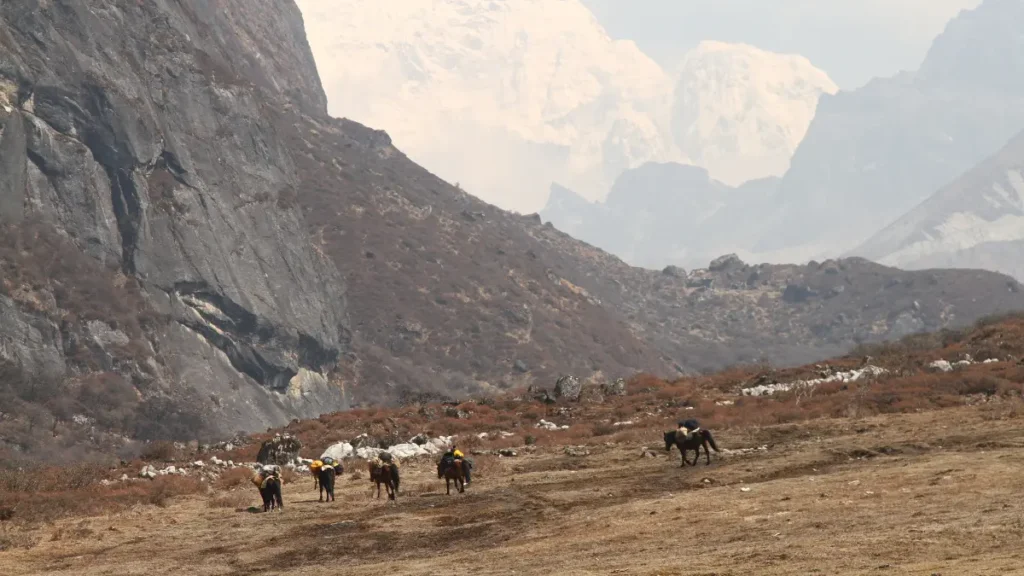
Tucked away in the Eastern Himalayas, the Goechala Trek is a captivating journey that offers breathtaking views of the powerful Mount Kanchenjunga, which proudly holds the world’s third-highest mountain title. Famous for the grandeur of its peaks and the variety of its surroundings, the walk takes lovers on an enthralling trip that passes through lush woods and into the country of snow-capped summits. It is a perfect refuge for both lovers of the outdoors and thrill-seekers.
The Goechala Trek begins in the sleepy West Sikkim town of Yuksom and travels through some of the Himalayas’ most remote and beautiful regions. It is 92 kilometres long! Trekking over high mountain passes and along clear rivers and streams, you get a close-up look at Sikkim’s diverse range of native plants, animals, and alpine dwellings.
Why Should You Do the Goechala Trek?
The climb to the Goechala viewpoint, an unmatched vantage point that offers a panoramic sight of neighbouring mountains and valleys, is a defining milestone in the Goechala Trek. From this high vantage point, the majestic Mount Kanchenjunga and its surrounding peaks present a sight that elicits awe and leaves a lasting impression. The Goechala Trek’s attraction is not limited to the actual route; it also includes the profound experience of taking in the breathtaking beauty of nature at the highest point in the Himalayas.
The natural beauty of the Goechala Trek is so magnificent that words cannot express it; it evokes an experience that cannot be spoken. This story offers a brief overview of the components that make this journey very fulfilling. Even while we might not be as poetic as romantic poets or writers who can transport you to another world with every word, we promise you one thing that cannot be denied: when you get to the perspective, the scene in front of you will bring you tears of joy.
Goechala Trek Difficulty Level
Due to its strenuous uphill and downhill sections and varied terrain, this excursion is best suited for experienced trekkers and requires strong physical fitness. However, even individuals not experienced with hiking may easily go on this trip with proper training and planning.
Highlights of the Goechala Trek – One of the Most Beautiful Treks in Sikkim
· One of the highlights of the treks in Sikkim is the dawn over the Kanchenjunga Range. Trekkers might not be able to reach the top of Goecha La Pass, but the spectacular view from the viewpoint and Dzongri is priceless.
· The rhododendron woods along the path add to the appeal of the walk. These forests blossom with a brilliant display of pink and scarlet flowers in April and May, creating a charming trail that enchants visitors at every turn.
· The stunning Samiti Lake is a noteworthy treasure on this hike. Its serene waters reflect the beautiful Mt. Pandim, creating a captivating scene, especially in the morning. The scene’s ethereal splendour is a visual feast for those lucky to see it.
Goechala Trek – Detailed Itinerary
Day 1: Yuksom
· The beginning of the Goechala trip, Yuksom in West Sikkim, is where the magic of most treks in Sikkim starts. In Yuksom, you must check in at the police station with three copies of your picture ID and pay for your permit at the forest check station before starting your walk. The costs come to about Rs. 700 per person, including extra costs for cameras, using a tent, porter, yak, etc.
Day 2: Yuksom to Sachen
Along the borders of the bush, hikers enjoy thirty minutes of sunshine as the Goechala walk unfolds. A shelter on the right indicates the halfway point to the first Pha Khola bridge. As you get closer to Pha Khola, the verdant forest welcomes you and provides a cool atmosphere along the slightly sloping, progressively rising path.
· For the following ninety minutes, the route winds through a lush forest, revealing to the left the spectacular waterfalls of Tshushay Khola, which pour into the Prek Chu River. A massive iron bridge marks the beginning of the ascent.
· An hour later, the Mentogang Khola is crossed by a short cement bridge that rises to 7,100 feet, and it takes twenty minutes to get to Sachen’s log cabin. Bigger gatherings can use the area across from the shelter, which is above the trail and has the soft rush of the hidden Prek Chu River.
Day 3: Sachen – Bakhim – Tshoka
· After thirty minutes, there’s a strong rise to the left of the bridge that takes you through mixed oak woods to the first rhododendrons. The sudden elevation gain makes the air seem cold. The route continues for another thirty minutes to Bakhim, one km from the Prek Chu River, but it feels farther away because of the terrain’s undulations. With its Forest Rest House and expansive views of the Yuksom Valley, Bakhim is a popular destination for hikers heading to Tshoka, which is around an hour away.
· Encircled by rhododendron trees at about nine thousand feet, Tshoka reveals itself 10 minutes later on a plateau with a roomy four-room wooden trekkers’ lodge that can house more than twenty hikers. Slightly higher lies the Forest Rest House, another place to stay.
Day 4: Tshoka – Phedang – Dzongri
Climb from the monastery pond to a vantage point where Tshoka is visible below, encircled by vivid red rhododendrons. The route levels out to a wonderful wooden log-paved promenade, reminiscent of a park with seats bordered by rhododendrons after a strenuous 30-minute ascent.
· With rhododendron trees covered with mist, the rough trail rises quickly to 13,000 feet Phedang, where stunning views of snow-capped peaks are available. A route that branches out to Kokchurang is present, along with lunch at Phedang.
· Choose the Dzongri path, beginning on the other side of the clearing. Climb past dwarf rhododendrons and, after an hour, reach the top at 13,080 feet, where prayer flags and a shrine may be found.
· The route descends to Dzongri after a short break, presenting the trekkers’ lodge at 12,980 feet. Hikers frequently arrive at Dzongri, encircled by the Pandim and Kanchenjunga peaks, and may return after taking in the amazing vistas.
Day 5: Dzongri – Dzongri Top – Dzongri
Start the day by ascending to the 13,670-foot Dzongri Top, the highest point providing an amazing 180-degree panoramic vista. The view is unmatched, with a view of the Singalila and Kanchenjunga ranges, including the peaks of Kakthong, Rothang, Kabru South, Kabru North, Kabru Dome, Pandim, and Lama Lamini.
· Reachable after an hour’s walk from Dzongri, the ascent to Dzongri Top starts at 4 AM under torchlight to guarantee you see the first rays of dawn caressing Kanchenjunga. The Singalila range opens up as you rise, leading to the magnificent sight of Kanchenjunga and its surroundings. Savour the captivating dawn and watch the mountains change colour as the sunshine hits them.
· Admire the view of the Goechala peaks below, with infinite green slopes of rhododendrons on the other side, and Thansing, your destination for the next day. It takes around half an hour to return to Dzongri. This step is crucial for acclimatization.
Day 6: Dzongri – Kokchurang – Thansing
After thirty minutes, the rhododendron bushes return to the hillsides, indicating a gradual to moderate decline that lasts for more than two hours. The dense rhododendron forest replaces the bushes, steepening the drop by more than 500 feet and creating a birdwatcher’s paradise. Birds disguised in the browns and greens of the woodland can be seen on a quiet stroll. At the bottom of the slope, Kokchurang appears; a woodland road to Phedang is on the right.
· There is a trekker house at Kokchurang, but if you want an even more magical experience, you may set up tents 50 metres along the Prek Chu River. The river is shrouded in mist in the evening, giving the campsite a mystical feel. The cabin features two trekker halls holding ten to twelve people each and a central hall where cooking is done.
· Enjoy the refreshing wind and crystal-clear blue water as you descend from Kokchurang to the Prek Chu River bridge. The rhododendron woodland is captivating on the opposite side; it seems like a stroll out of a fairy tale. Halfway up the 2-kilometre climb to Thansing, the stony, desolate terrain gives way to a large meadow in front of Mt Pandim and the left wall of Kanchenjunga. Though Thansing’s wide meadow welcomes many tents and offers a wonderful view of the towering peaks, it can be chilly at night.
Day 7: Thansing – Samiti Lake – Viewpoint – Thansing
Think about hiking an extra hour to Samiti Lake, a difficult 45-minute ascent from Thansing. The climbing continues on rugged terrain until the abrupt levelling off reveals Samiti Lake’s crystal clear blue waters. Waves may form in the lake when it’s windy. Explore the lakeshores, a popular hangout for bluebirds and mountain goats.
· Start the longest day early, at midnight, for several benefits: see the dawn over Kanchenjunga at the first viewpoint, cross the snow-covered moraines, have a better chance of bright morning views, and have enough time at ViewPoint 1 before heading back to Samiti by 8 AM.
· There are two portions of the somewhat steep route leading to ViewPoint 1: one goes up to Samiti Lake, while the other leads directly to ViewPoint 1. The day’s highlight is the stunning dawn above the Kanchenjunga range, with the gentle alpenglow leaving a lasting impression.
· Photographers will find the clear mountain reflection at Samiti Lake in the early morning hours particularly fascinating. Plan to return to Samiti by 8 AM so that you may spend an extra hour by the lake. From there, make your way back to Thansing.
Day 8: Thansing – Kochurang – Phedang – Tshoka (The Return Journey)
Choose the woodland detour to the left rather than the climb up to Dzongri. Rhododendron trees line the fairly level route, with few descents and ascents that alternate between mountains. The Prek Chu River runs below. Admire breathtaking vistas of Mount Pandim and its surrounding areas as you go. It takes around 4 hours to cover the 10 km to Phedang, one of the longest stretches between campgrounds.
· The unique first part offers an interesting experience as it meanders down the mountainside at a constant elevation of 12,000 feet. Phedang, Kokchurang and many of the paths share this height.
· Take a different route down from Phedang to Tshoka. The walk takes 8 to 9 hours daily, offering a varied and interesting experience.
Day 9: Tshoka – Bakhim – Sachen – Yuksom
· Take a quicker and easier route from Tshoka to Yuksom than you did on your first ascent. Sachen descends quickly and pure. The path progressively loses height with its alternating ascents and descents. Though there are a few rises in the last stretch that may cause you to hesitate, they are short, and before you know it, you’ll be back in the friendly environs of Yuksom, surrounded by its friendly neighbourhood.
Goechala Trek Best Time
The best times to do the Goechala Trek are in the pre-monsoon months of March through early June or in the post-monsoon months of late September to November. These times of year offer consistent weather, bright skies, and comfortable hiking temperatures. The visual attraction is further enhanced by the blooming of vivid rhododendrons in spring, which occurs during the post-monsoon months that provide lush green landscapes. Good visibility is available in both seasons, guaranteeing stunning views of the Kanchenjunga range. The monsoon season, when the paths can be slick, and the winter months, when there is a lot of snowfall, are best avoided. Always check the trail’s state and current weather to ensure your trekking trip is safe and pleasurable.
It would help if you did the Goechala Trek, one of the best treks in Sikkim, between March and June.
Conclusion
Goechala trek is one of the most sought-after treks in Sikkim that one must not miss out on when travelling to the beautiful state. This 92-kilometre-long 9-day trek is well worth the effort, we promise!


